
- TOP
- Cutting-edge Research and Social Contribution
- Cutting-edge Research
- If roads are cut off, where should they be reconnected first? A disaster-resilient transportation network derived from equations
If roads are cut off, where should they be reconnected first? A disaster-resilient transportation network derived from equations
SUGIURA Satoshi
- Specialized field
Infrastructure Planning and Management, Operations Research
- Our daily lives are profoundly affected by transportation networks such as roads, railways, and bus routes. The economy functions because people and goods move smoothly, and when disaster strikes, the inability to secure transportation threatens lives and livelihoods.
Professor Satoshi SUGIURA of the School of Systems Engineering is scientifically analyzing these familiar yet complex urban connections and exploring what a more efficient and disaster-resilient transportation network should look like.
The starting point of Professor Sugiura's research is to reconceptualize the city in terms of points, lines, and flows. By organizing intersections, transportation stops, and evacuation shelters as points, roads and routes connecting them as lines, and movement of people and goods as flows, the overall structure of the city is brought into theoretical relief. He then uses mathematical optimization techniques to derive the design of the transportation network that is best for the city as a whole. In effect, he strives to redraw, through equations, the form of the cities that support our daily lives.
Designing connections, not buildings
Professor Sugiura leads the Urban Network Design Laboratory. From the name, one might imagine arrangement of buildings or the design of spaces. However, what is designed here is not visible buildings, but the network structure itself that links them together and allows the city to function.
Limited budgets, deteriorating infrastructure, future population decline, and the risks posed by disasters: under these real-world constraints, what locations should be connected, which should be kept, and which should be reduced? He also asks in what order development and renewal should proceed to be most rational. The aim is to think theoretically about how to design the "connections" that form the framework of a city so that they can be sustainable.
"For example, if we could add just one new road to the current road network, where should it go to maximize the benefit to the city as a whole? Conversely, if maintenance management has reached its limit and we have no choice but to reduce the number of roads, which road should be removed to keep inconvenience to a minimum? We translate such questions into mathematical formulas and derive the optimal solution for what the road network of the future ought to be."
This approach applies to public transportation as well. Rather than discussing bus routes in the simple binary of keep or eliminate, it uses mathematical models to evaluate what kinds of routes should operate, and at what frequency, while minimizing inconvenience to users. Instead of relying on intuition or rules of thumb, it seeks to determine the form of the network that is just right on the basis of quantitative evidence. Professor Sugiura is working to build a theoretical framework for this purpose.
A new mathematical model for preventing the isolation of communities
Research that scientifically examines these urban connections not only improves efficiency in normal times, but also provides a foundation for protecting lives and livelihoods in times of disaster. In highly disaster-prone Japan, earthquakes, torrential rains, and landslides have repeatedly cut off roads and isolated communities in mountainous and peninsular regions, leaving relief supplies unable to reach them. Recent large-scale disasters have once again brought the risk of such isolation into sharp focus.
"If evacuation shelters and supply bases themselves become isolated, then no matter how strong the will to provide aid is, it will not reach the people who need it. My idea was that we must first understand quantitatively which places are more likely to become isolated."
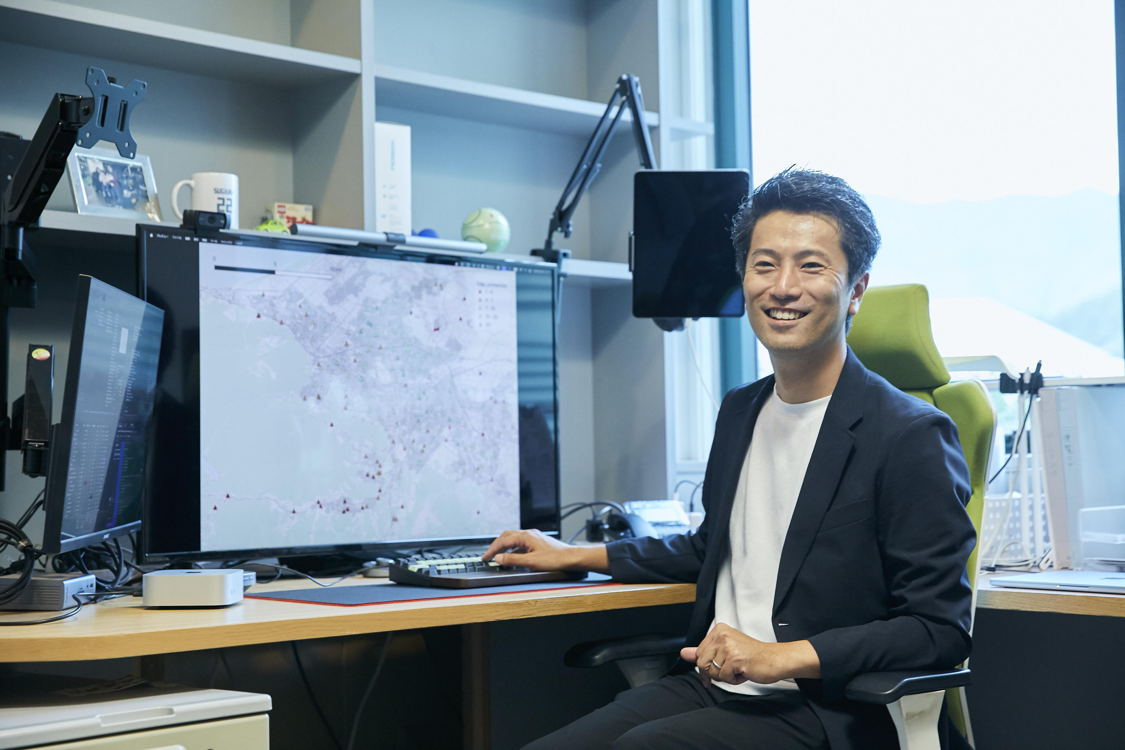
In previous research, no method had been established for evaluating which areas within a large road network were likely to become isolated during a disaster. Professor Sugiura therefore focused on a new approach that combines graph theory, which treats roads and facilities as points and lines in a network, with mathematical optimization techniques, which are used to derive the most efficient solution.
The idea itself is very simple. If we imagine an "evil demon" who can freely destroy roads at will, then the question becomes: what is the minimum number of roads that have to be destroyed to completely isolate a given evacuation shelter? A shelter that can be isolated by destroying three roads is clearly more vulnerable than one that can only be isolated by destroying 10 roads. By calculating this minimum number of destroyed roads as an index, it becomes possible to express vulnerability to isolation in numerical terms.
The challenge was how to carry out the calculation within a realistic amount of time. Actual cities contain huge numbers of roads and facilities, and a method that simply checks every possible combination of routes would take an extremely long time to compute. Here, Professor Sugiura succeeded in skillfully transforming the network structure and formulating the problem as the "minimum cut problem," a classical topic in mathematical optimization. By setting virtual starting and ending points and organizing the relationships between multiple support facilities and evacuation shelters into one-to-one problems, it became possible to calculate vulnerability instantly even for large cities.
When this method was applied to designated evacuation shelters in the city of Sapporo, it was found that multiple shelters would become isolated with the destruction of four roads or less. Particularly notable were new towns with limited connections to arterial roads, and a similar tendency was also observed in hot spring areas in mountainous regions. It was further confirmed that some schools located in mountain areas also faced a high risk of isolation.
"Even residential areas and public facilities that appear safe at a glance may be highly prone to isolation from the standpoint of network structure. I believe one result of this work is that it has made it possible to visualize mathematically these vulnerabilities that are difficult to perceive intuitively."
This method has direct implications for revising the siting plans of evacuation shelters and supply bases, identifying roads that should be reinforced as a priority, and identifying vulnerable facilities on hazard maps. It is precisely this high degree of practical applicability, i.e., the ability to directly contribute to municipal disaster prevention planning, that makes this research particularly significant.
Shifting the optimal strategy for disaster recovery from dynamic to static
Evaluating isolation risk in advance is important. However, in actual large-scale disasters, there are situations where that alone is not an adequate response. When a wide area and a large number of roads are damaged simultaneously, as in the Noto Peninsula earthquake, the priority shifts beyond the question of "how many roads have to be destroyed for isolation to occur" to the far more urgent issue of "how to reconnect the roads as quickly as possible."
"When I saw the situation on the Noto Peninsula, I realized it was not the time to talk about the minimal number of roads that would have to be destroyed for isolation to occur. When the damage is that extensive, what matters above all is how quickly you can reconnect."
What then emerged was the problem of how to determine the order of road clearance, that is, the order in which roads should be reopened to traffic. In the immediate aftermath of a disaster, road clearance is regarded as a dynamic problem, because the state of connectivity changes with time and the recovery process.
"As heavy machinery is dispatched from recovery bases and roads are successively reopened, choices arise at every branching point, such as whether to proceed to the left or the right, and each choice changes the options available next. The farther the work progresses, the more the possible combinations proliferate, and with conventional methods there was a limit to the scale that could be handled."
To address this difficult problem, Professor Sugiura shifted his way of thinking. "If an optimal road-clearance plan exists, then it must necessarily satisfy certain properties." Taking that hypothesis as his starting point, he theoretically unraveled the structure of the problem one element at a time.
The results showed that, as a rule, a single clearance route is sufficient to eliminate the isolation of an isolated community, and that there is no need to provide multiple routes. Once a single route is specified, an order naturally emerges in how recovery should proceed, and an upstream-downstream relationship comes into existence among the routes. In this way, the countless branching options become much more organized.
It also became clear that the optimal clearance plan converges on a specific tree structure called a Steiner tree. By taking this structure, which connects multiple points at minimum cost, as a premise, the problem--which had been dynamic and difficult to handle--was transformed all at once into a more manageable static problem.
Supporting this theory is an index independently introduced by Professor Sugiura called cumulative isolation time. If, for example, 10 communities are isolated when a disaster occurs, that number decreases to 9, then 8, as road-clearance work progresses, and eventually reaches zero. If this index is plotted along a time axis, an area like a triangle appears, representing the period over which isolation continued. The smaller this area, the shorter the total time residents remained isolated, and the higher the evaluation of the road-clearance strategy.
By formulating the problem as minimization of this cumulative isolation time, it became possible to derive the optimal road-clearance sequence within a realistic amount of time even with a large-scale network.
That said, this model does not take traffic volume into account, and is based on the premise of first securing a road allowing passage of even a single vehicle. For that reason, arterial roads are not always given priority, and in some cases narrow neighborhood roads may be selected instead. As a result, once traffic resumes, the way roads are used may change dramatically, and situations may arise that cannot be fully addressed by road clearance alone.
This research is now moving in the direction of examining clearance routes that minimize initial disruption as much as possible--for instance, by incorporating conditions that prioritize arterial roads in the stage immediately after a disaster--in collaboration with researchers from other fields who study methods for predicting how many days clearance will take.
The frontier of recovery phase transportation, opened up by data
Even when roads can be reconnected, the challenge of how to support traffic flow afterward remains. In the process of transitioning from disaster response to reconstruction, the very role that transportation plays undergoes significant change.
Research into traffic during disasters began in earnest over the past fifteen years or so. In the past, it was difficult in itself to grasp in detail which roads were passable or where there was congestion during a disaster. However, advances in observation technology--exemplified by ETC2.0--have made it possible to quantitatively capture traffic conditions during disasters through vehicle travel data.
Against the backdrop of this changing environment, Professor Sugiura has set his sights next on analysis of the recovery phase, including transportation demand that continues to change as recovery progresses. This is a phase situated, so to speak, between disaster conditions and normalcy, in which daily life resumes while roads have not yet been fully restored.
"Compared to the response in the emergency stage immediately after a disaster strikes, transportation during the recovery phase is more prone to panic, and yet no established methods exist for handling that issue. Actually, however, this recovery phase is itself a critical juncture that determines whether people can rebuild their lives."
If narrower roads are prioritized for clearance, isolation can be resolved comparatively quickly. However, past disasters have repeatedly shown that severe congestion results when commuting, logistics, and relief activities all begin at once under these conditions. On top of that, an influx of supporters--including volunteers, recovery contractors, and government staff--causes transportation demand to take on a form entirely different from ordinary times, and it fluctuates dramatically as time passes.
Assuming this "hard-to-decipher demand variability," which roads should be restored in what order, and where should traffic be directed, so as to suppress congestion while supporting the rebuilding of people's lives? Professor Sugiura is trying to elucidate the full picture by treating the process in which network restoration and demand changes mutually influence each other as a single dynamic system, and using an approach that optimizes traffic flow while carrying out review in stages according to changes in the situation. Delineating the forms of transportation as it transitions from disaster response through reconstruction and back to everyday life is the next frontier.
"Now that we've reached the point where data can be used, I feel we need to predict what can happen and define what 'good condition of the roads' actually means."
The origin of Professor Sugiura's engagement with disaster research lies in the 2011 Great East Japan Earthquake. At the time he was working as a company employee, and the scenes from the disaster-affected areas he witnessed through live television footage left him with a profound sense of helplessness. That feeling gradually transformed into an urgent conviction that something had to be done.
Then, roughly two weeks after the earthquake, he heard a researcher from Kyoto University speak before the National Diet. That gave him a clear understanding of the magnitude of the role civil engineering had to play, and that became the decisive factor that set him on the path to becoming a researcher.
Since then, he has continued his research while continually questioning how transportation and infrastructure should be managed during disasters, and in the spring of 2025 he relocated his base from Hokkaido to KUT. Kochi Prefecture, which faces the risk of a Nankai megathrust earthquake, is both a region at the leading edge of disaster research challenges and a microcosm of the rural cities where population decline and infrastructure deterioration are intensifying.
"Having lived in Kochi, I strongly felt both the insufficiency of road infrastructure and the uncertainty of how hard the future is to read."
Traffic is concentrated on limited flat land, and chronic congestion occurs during commuting hours. At the same time, building new roads would place a heavy burden of construction and maintenance costs on future generations. Moreover, if new mobility technologies such as flying cars become widespread in the near future, the value of the current road network itself could change.
That is precisely why the crucial point going forward is not simply expansion, but infrastructure planning that looks ahead to scaling back in the future.
"Roads that may fall out of use in the future should be designed beforehand in forms that are easy to downsize. Taking into account the lifespans of infrastructure, such as bridge renewal timelines, we need to think strategically about when and where to consolidate. Furthermore, we need to think about how to support mobility across an entire region, including not only roads but also public transit. Presenting such soft-landing strategies in the form of mathematical models looks set to become an important theme going forward."
What Professor Sugiura cites as the greatest reward of research is the moment when a problem he had thought too complex and intractable suddenly falls into place as a surprisingly simple equation due to the introduction of a new perspective. A phenomenon that had been hard to solve is turned into a formula, and a clear prospect emerges for treating it as a real-world problem. The solid sense of traction felt at that moment, he says, is what drives him to keep researching.
While much research trends toward ever greater computational sophistication and intricacy, Professor Sugiura first reexamines the very structure of a problem, carefully stripping away elements that are not essential. It is precisely this stance--identifying what is truly important and simplifying a problem to its ultimate limits--that is the strength of his research.
Underlying all of this is a simple and honest desire to build a society where people can live with peace of mind. That said, he describes it as feeling "less like trumpeting that as a grand slogan, and more like solving the concrete problems right in front of me, one at a time, through equations."
His vulnerability assessment models for isolated communities and his optimization methods for road clearance already have the potential for use in municipal disaster preparedness plans and infrastructure policy. That is precisely why it is important to go beyond publishing academic papers, deliver findings in forms that reach municipal officials and policymakers, and work toward having findings incorporated into actual plans.
"In terms of my true self, I'm the type who would rather sit quietly at a desk and solve equations."
He says that with a laugh, but he feels a strong sense of responsibility to give back to society the fruits of his research, given that he is continuing his research in Kochi, a region with high disaster risk.
He is sorting out the structure of problems within the world of equations, then translating those results into concrete forms such as actual roads, bus routes, and evacuation shelters. Moving back and forth between theory and practice, he will continue tackling the challenges of designing disaster-resilient, flexible, and sustainable urban connectivity from the front lines of Kochi.
Date of posting: January 2026 / Date of interview: October 2025